

ABOUT OLD GOAT AERIAL SERVICES
Veteran-owned precision thermal drone services for North Texas.
Nathan Bricker is a retired United States Navy LCAC Hovercraft pilot and the owner of Old Goat Aerial Services in Fort Worth, Texas. With 18 years of marriage, three children, and a lifelong passion for the outdoors, Nate brings military-precision flying, advanced thermography expertise, and real Texas land-management knowledge to every mission.
As a licensed FAA Part 107 Remote Pilot, Level 1 Thermography technician (Clemson Drones), and holder of the Texas Parks & Wildlife Department Aerial Permit, he delivers accurate, legal, and professional thermal drone services statewide — specializing in wildlife & herd management, MLDP deer surveys, livestock search & rescue, thermal guided hunts, agriculture mapping, and construction time-lapse.

.png)

Veteran Owned
Retired Navy LCAC Pilot
Level 1 Thermography
Clemson Drones Certified

TPWD Aerial Permit
Statewide Operations


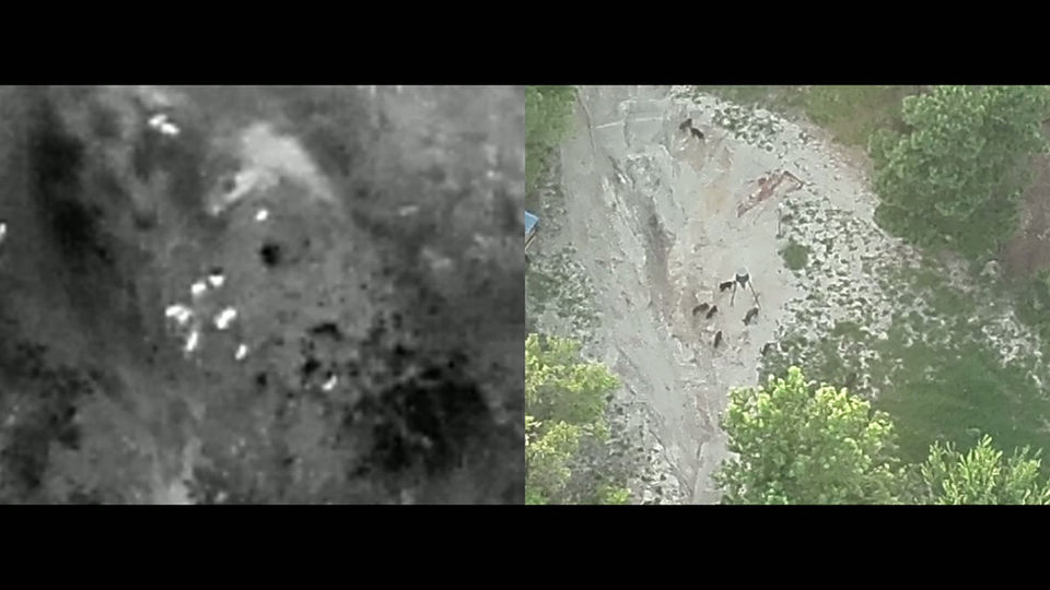


Thermal Wildlife & Herd Management
Accurate MLDP deer surveys, population counts, buck/doe ratios, and habitat assessment using professional thermal drone imaging.
Livestock Search & Rescue
Fast thermal drone missions to locate missing or injured cattle and livestock in dense brush or at night.
Agricultural Land Mapping
High-resolution aerial mapping of pastures, fence lines, water sources, and terrain for better ranch and farm management.
Construction Time-Lapse
Professional drone time-lapse videos and progress monitoring for barns, infrastructure, and ranch construction projects.
Benifits of a Professional Survey
Texas Managed Land Deer Program (MLDP)
Extend Your Hunting Season & Receive More Tags
Texas Wildlife Exemption
Save Money on Property Taxes
Wildlife Management Planning
Total Counts, Buck-to-Doe Ratios, Fawn Crop & Retention
Property Valuation
Accurate Population Numbers Help Buyers and Sellers
Perimeter Surveillance
Property Perimeter security/surveillance